Ultra relay along Seattle's 1 Line
by Race Condition Running. 08:30 September 27th
Team registration closed September 25th • - teams registered
Ultra relay along Seattle's 1 Line
by Race Condition Running. 08:30 September 27th
Team registration closed September 25th • - teams registered
Light Rail Relay is an unsanctioned urban relay along Sound Transit's 1 Line. Teams of runners and walkers make the journey from Angle Lake to Lynnwood. The event is held annually in late September.
The relay will start at Angle Lake station and follow the 1 Line to Lynnwood, visiting every station on the way. The route passes through 6 cities across 2 counties.
We are using Pantograph for registration this year. Pantograph was tailor-made for team relays, and also lets your team upload exchange photos for timing purposes.
Create a new team and invite others to join.
Team of one. Save the fare, just run the whole way.
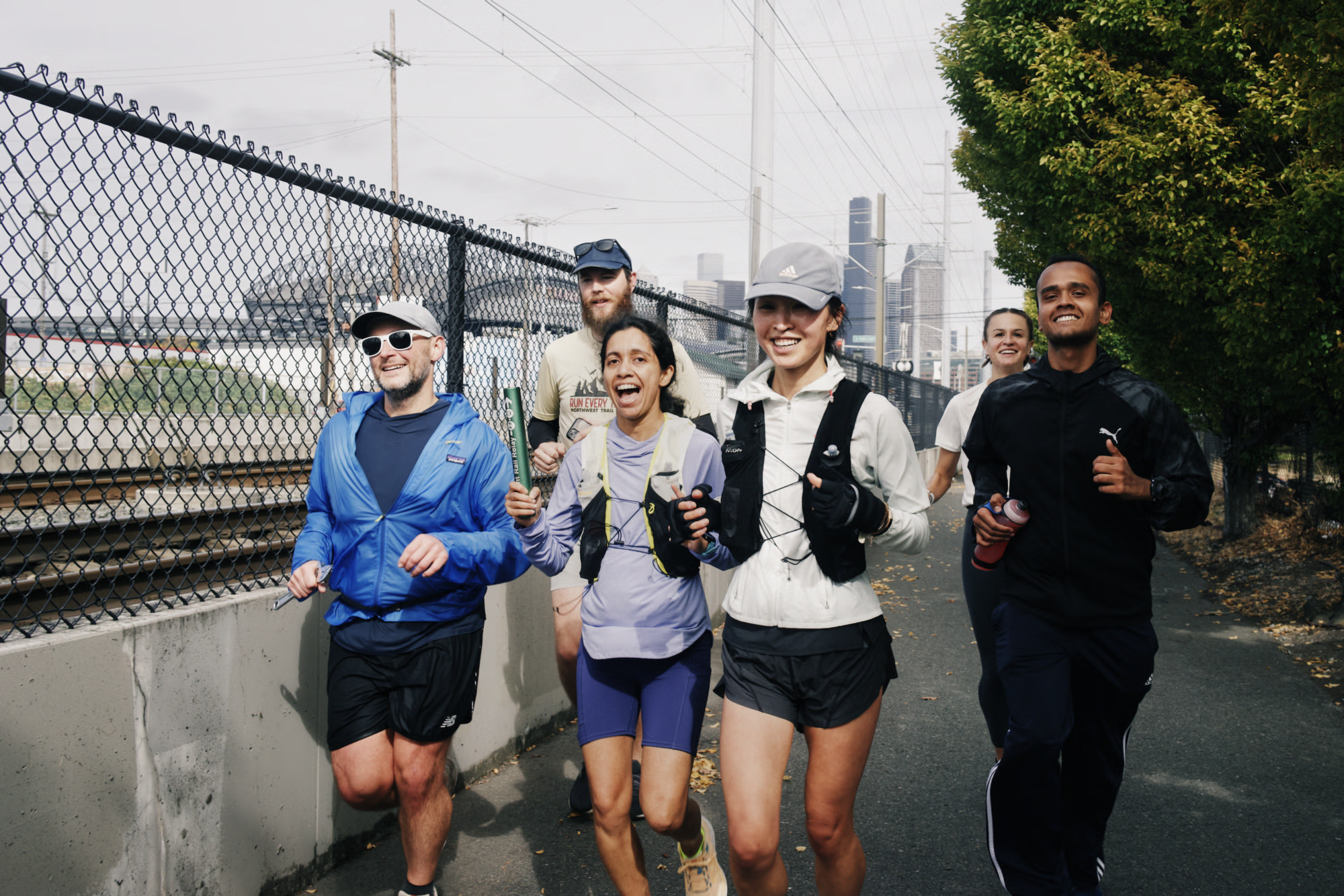
It's a chance to see different parts of the city with your friends, and to accomplish something together that you couldn't otherwise. If you're an ultra-runner, maybe you're keen on establishing Seattle's first great urban FKT. Or maybe you like the idea of racing trains. Check out the photos from last year if you still need convincing.
Past runners have said the event gave them a new view of the city and a fresh appreciation for the Link.
Besides, every city worth its salt has a run along a train. Make the most of it.
The 2 Line (and the T Line) don't yet connect to the 1 Line, so we'd need to start the event in multiple locations without an easy connection between. We've decided to focus on the longest line for now, but you can expect changes as the system continues to expand and connect.
No, none of the above. The event is too small (headcount) and too long for that to pencil out. The relay is mostly an excuse for you to hang out with your friends. See the logistics notes for advice on managing without course support.
If you're interested in sponsoring any of these things for future Light Rail Relays, please reach out!
Anyone can form a team to complete the relay. See the instructions below for making a team.
Anyone in the UW CSE community is welcome to run as part of the Race Condition Running team. Look for information in the UW CSE Slack.
Decide which format you'd like to participate in. There are three categories for results purposes: Competitive for teams of six, Solo for teams of one, and Open for all other formats. All teams will:
Teams are responsible for their own logistics and support during the event.
If you're interested in forming a team, please complete the team signup. The registration fee covers a custom event baton. Once your team is confirmed, you and your runners will be able to use the main sign-up form.
Yes, your team can walk for any or all of the event. There will be about 12 hours of usable daylight. Please mark your estimated time appropriately when registering as walking teams will be given an earlier start.
If you want an official time, your team will need to upload 23 station photos with time metadata on Pantograph. We'll verify the photos and post the results. The photos you share will not be posted.
Your baton must be in the photo. It must be possible to tell that the photo was taken from within 100m of the station platform as the crow flies. You don't need to take the photo on the platform or even from within the fare zone! Use the station art or signage. Zoom into the map to see our recommended exchange landmarks.
We prefer photos contain at least those who started/ended/ran-through a station, so we have documentation for who ran what.
We strongly recommend you follow the given route. We've run it before and assembled notes on what to expect. That said, the course is not monitored, and we will only be checking station photos. You can run alternative routes at your peril.
There are no constraints. The RCR team treats the event like a big long-run, with multiple runners on each leg. See our previous schedules from 2021 and 2022 to get the idea. In any case, we'll collect your runners' preferences and send them to you along with a recommended schedule.
If you're looking to set a course record, your team must have exactly six runners each running at least one leg. So you may exchange as few as five times or as many times as there are stations. A mixed team is 3 men and 3 women, and a womens' team is 6 female runners.
Participating in Light Rail Relay involves the same kinds of danger that you would encounter on any run in Seattle. Although unlikely, there is risk of harm from vehicle traffic, falling, weather, or medical complications. The course is open, and you are responsible for your own safety. During registration, you will be asked to sign a liability waiver acknowledging these risks. That being said, the organizers have run the route multiple times without incident. Click around the route map to see our notes.
You're likely to only have one person running each leg, so it's easiest if the folks who aren't running ride the train together to the next handoff. The train is your Ragnar van.
Our experience with a team of 20+ and multiple runners assigned to each leg is that a shared schedule spreadsheet helps a lot. You can see RCR's from 2022 and 2023 as examples. If you're planning to participate in this "club run" format, we'll provide a recommended schedule based on your runners' preferences, but it's up to the team captain (person who added the team) to finalize and distribute assignments.
It's possible to run the ~58k route unsupported. Otherwise, there are many shops along the way for supplies (zoom into the map to see data from OpenStreetMap). Here are some within 100ft of the route:
Seattle's shameful lack of public restrooms means libraries are your safest bet. The Beacon Hill Branch is only a block off the course and will be open in time for most runners, as will the Central Library downtown on 4th Ave. Note that University Branch on Roosevelt is closed until 2026. Check the Seattle Public Libraries page for up-to-date info. Stations from Northgate northward have restrooms, but they are not always in service. Some of the above stores may have restrooms available, and you can zoom into the map to see other restrooms from OpenStreetMap. Do not count on access to any restrooms on the UW campus on weekends.
The map includes OpenStreetMap water fountain information, but the presence and function of fountains changes often. Seattle Public Utilities has a map with the status of their fountains.
Exchanges: The easiest way is to meet at the exact points marked on the route. We've placed the markers next to station art, signage or other landmarks. Zoom into the map to see our recommended exchange landmarks.
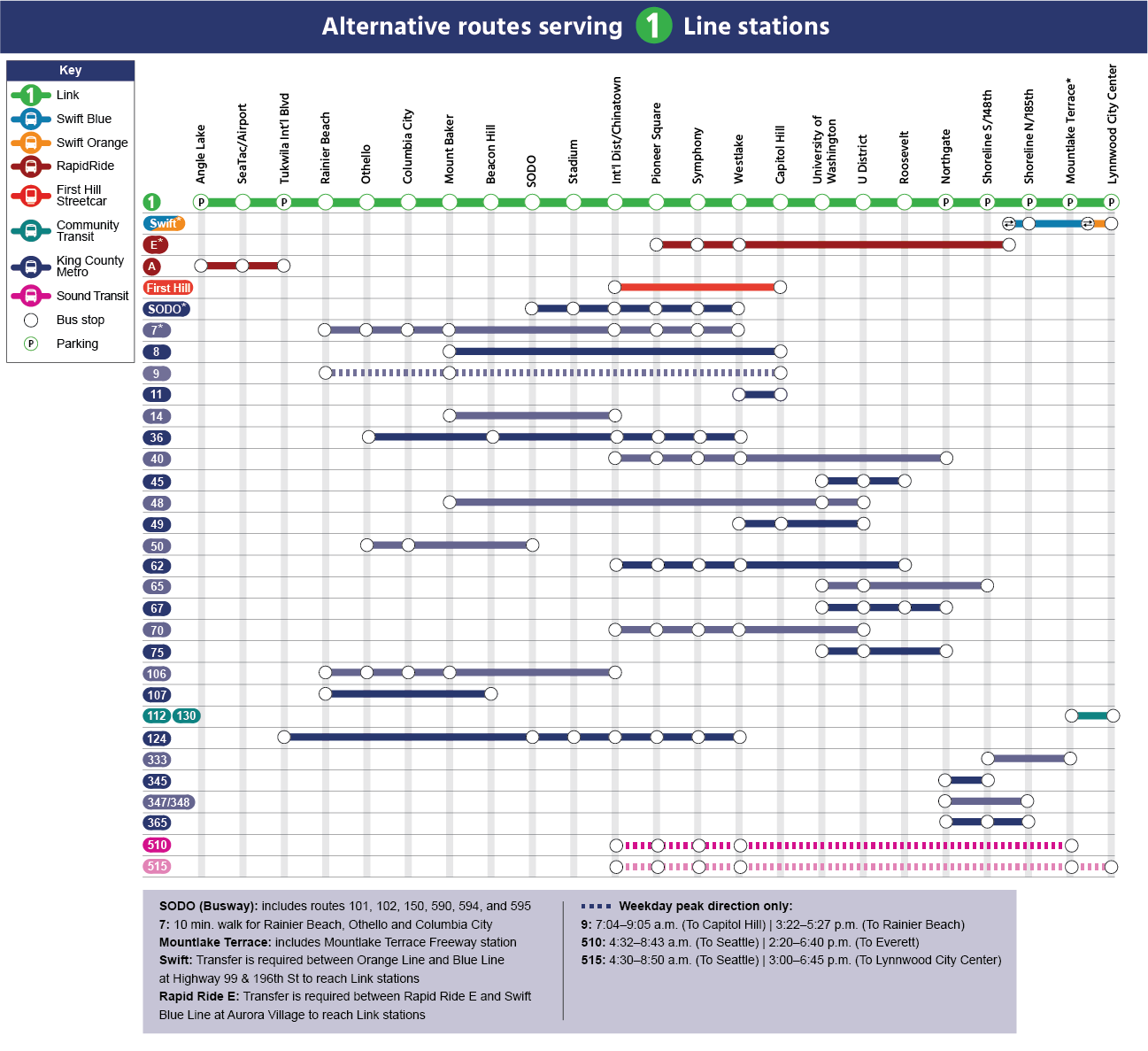
Getting around: conveniently, exchanges are accessible via light rail and bus. See Seattle Transit Blog's page for a refresher on how to get around using transit, and check the ORCA site for recommendations on how to purchase fares. UW students can ride for free using their Husky IDs.
Team captains are your main point of contact. Here are the emails they've been sent:
Hello LRR25 Captains,
Here's what to expect. This brief and the previous will also be on the site if you need to reference them. See also: the FAQ.
Reminders from previous brief stand. If your team size doesn't match your results images, your times may be struck. Have people register. They can join your team anytime, even the morning of. If you want to indicate to me that your roster is complete, you can "Close" your team.
Have your team study the map and especially the warnings. In addition to those marked, you can expect some minor sidewalk narrowing/detours along MLK ~Othello as well as along Pine ~Capitol Hill. Every runner must be prepared to navigate their legs. There are >100 people running, but the course is very big. Depending on your team's pace, it is possible you won't see others after the start. If you want to guarantee meeting people, come to Angle Lake early.
If you registered with a previous baton, don't forget it! There won't be extras at the start.
Someone will stay back about 15 minutes after the start in case your start runner is late. After this point, you will run without a baton.
The latest 1 Line trip you should plan to catch to the start is the 6:58 from Lynnwood
Run, but also hang out with your team! Plan ahead if you're going to stop somewhere for coffee. If your team cares about results, post exchange photos to Pantograph. See previous email for instructions.
There are many food options a short walk from Lynnwood station. Consider getting a banh mi with your team. I will be around the hummingbird (finish line) for a few hours to say hi, but based on your time estimates, some of you will beat me there. Sorry if I miss you!
It will be warm toward the end. Please prepare appropriately.
SeaTac        8:00 AM    56°F (13°C)    Overcast clouds
Tukwila       9:00 AM    61°F (16°C)    Overcast clouds
South Seattle 10:00 AM   65°F (18°C)    Overcast clouds
Seattle       11:00 AM   69°F (21°C)    Broken clouds
Green Lake    12:00 PM   71°F (22°C)    Clear sky
Shoreline     1:00 PM    73°F (23°C)    Clear sky
Lynnwood      2:00 PM    75°F (24°C)    Clear sky
Please let a loved one know that you are running and your ETA. The course isn't monitored. If you are injured or lost, you'll never be far from city help/emergency services but I won't know what happened. If you drop, send me an email so I can sleep Saturday night.
Nick Walker
Hello LRR Captains,
Hope you and your team are almost set for next weekend's run. Three items as you plan:
Additional details to come mid-week.
Nick Walker